

Maybe you are asking, 'how many barangays does Taguig have?' This is your guide for Taguig City's official barangays.
Taguig is politically subdivided into 28 barangays. In December 2008, ten new barangays were created in the city after a successful plebiscite by virtue of City Ordinance Nos. 24–27, 57–61, 67–69, and 78, Series of 2008.
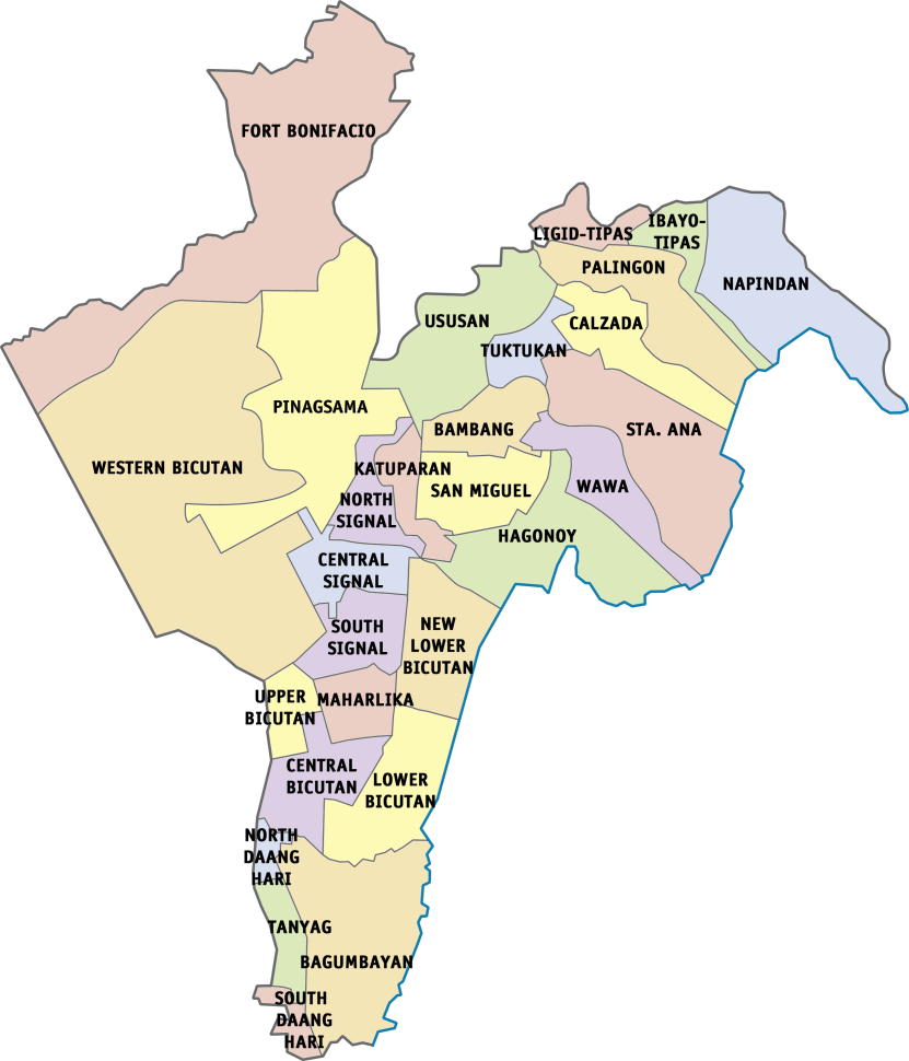 |
| Taguig Map with Barangays |
Taguig First District
- Bagumbayan
- Bambang
- Calzada
- Hagonoy
- Ibayo Tipas
- Ligid Tipas
- Lower Bicutan
- New Lower Bicutan
- Napindan
- Palingon
- San Miguel
- Santa Ana
- Tuktukan
- Ususan
- Wawa
 |
| The Philippine Coast Guard Base located in Brgy. New Lower Bicutan |
In 2008, Lower Bicutan was divided into two, the other one to be known as Barangay New Lower Bicutan. Parts of Hagonoy became under the jurisdiction of a new barangay San Miguel.

Taguig Second District
- Central Bicutan
- Central Signal Village
- Fort Bonifacio
- Katuparan
- Maharlika Village
- North Daang Hari
- North Signal Village
- Pinagsama
- South Daang Hari
- South Signal Village
- Tanyag
- Upper Bicutan
- Western Bicutan
 |
| The famous Bonifacio Global City or BGC is part of Brgy. Fort Bonifacio |
Signal Village was divided into four barangays, Central Signal Village (originating barangay), Katuparan, North Signal Village, and South Signal Village.
Bagong Tanyag was divided into three barangays, North Daang Hari, South Daang Hari, and Tanyag proper (originating barangay).
Parts of Upper Bicutan became under the jurisdiction of a new barangay Central Bicutan.
Western Bicutan was divided into three barangays, Fort Bonifacio, Pinagsama and Western Bicutan (originating barangay).
RELATED: Taguig Barangays and their official Facebook Page accounts
List of Taguig Barangays in alphabetical order:
- Bagumbayan
- Bambang
- Calzada
- Central Bicutan
- Central Signal Village
- Fort Bonifacio
- Hagonoy
- Ibayo Tipas
- Katuparan
- Ligid Tipas
- Lower Bicutan
- Maharlika Village
- Napindan
- New Lower Bicutan
- North Daang Hari
- North Signal Village
- Palingon
- Pinagsama
- San Miguel
- Santa Ana
- South Daang Hari
- South Signal Village
- Tanyag
- Tuktukan
- Upper Bicutan
- Ususan
- Wawa
- Western Bicutan
TAGUIG CITY'S GEOGRAPHY
Taguig is located on the northwestern shores of Laguna de Bay, the largest lake in the Philippines. Taguig River, a tributary of the Pasig River, runs through the northern half of the city, while the Napindan River, another tributary of Pasig, forms the natural border between Taguig in Pasig.
A relatively small area of the city called Ibayo Napindan is located north of the river, adjoining the disputed territories between Pasig, Taguig and Taytay in Rizal Province. The city has an area of 53.67 square kilometers.
ALSO IN TAGUIG
IMPORTANT NOTE: ang Taguigeño blog ay hindi konektado sa anumang account ng Taguig City government. Ito ay nabuo upang maghatid ng napapanahong balita at impormasyon para sa lahat ng Taguigeño.
WHERE TO STAY IN TAGUIG:
TAGUIGENO IS NOW ON YOUTUBE!
Image of Taguig barangay map Taguig barangay map Image of Taguig City map Taguig City map Feedback taguig population per barangay 2022 taguig barangay number taguig city district 1 barangays taguig district 2 barangays taguig districts district 4 taguig list
Post a Comment